Welcome to GISWeekly!
GISWeekly examines select top news each week, picks out worthwhile reading from around the web, and special interest items you might not find elsewhere. This issue will feature Industry News, Top News of the Week, Acquisitions/Agreements/Alliances, Announcements, People, New Products, Around the Web and Events Calendar.
GISWeekly welcomes letters and feedback from readers, so let us know what you think. Send your comments to me at giscafe-editor@IBSystems.com
Best wishes,
Susan Smith, Managing Editor
Industry News
GIS Applied to Chaco Canyon, New Mexico
by Susan Smith
 [
Click to Enlarge ] [
Click to Enlarge ]
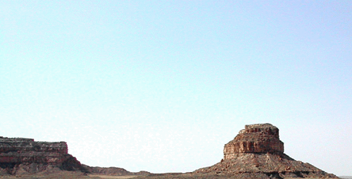
Fajada Butte |
Sofaer was joined by speakers Bill Stone, national advisor for the State of New Mexico and the National Geodetic Survey, and Rich Friedman, GIS supervisor, for the City of Farmington, also working for the Project.
 [
Click to Enlarge ] [
Click to Enlarge ]
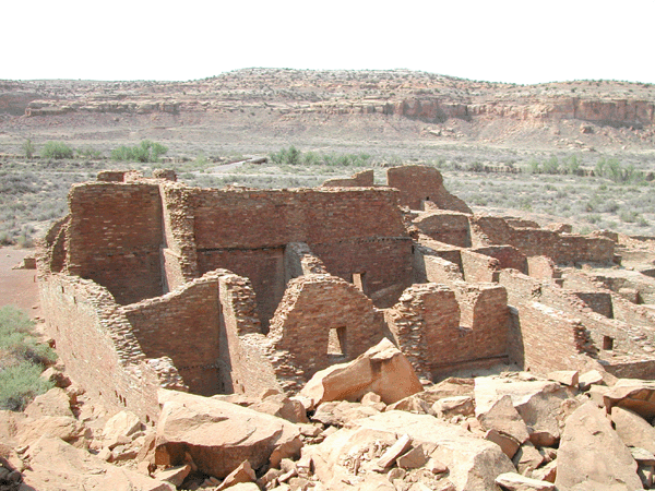
Pueblo Bonito |
Sofaer became acquainted with Chaco Canyon a week after summer solstice in 1977 when she joined a group of rock art recorders led by climber Jay Crowdy. Fajada (“Banded Cliff”) Butte, a butte that rises 380 feet above the valley floor in an almost perfect north-south, east-west axis, stands in a two-mile wide gap between two mesas which form the south wall of Chaco Canyon. Upon climbing the butte, which in itself is a feat not to be attempted without rock climbing equipment, Sofaer and the other recorders noted the views of Chaco Canyon and also ruins of approximately 20-30 dwellings.
 [
Click to Enlarge ] [
Click to Enlarge ]
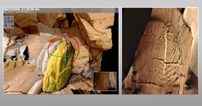
Sun Dagger |
How ancient people were able to ascend the butte is just one aspect of a larger mystery. In recent years, evidence of a large ramp built on the southwest face of the butte suggests there was once an easier way up. The ramp was believed to have been constructed in three sections. The 3-slab so-called Sun Dagger site is located at the foot of the uppermost 40 foot high cliff band.
 [
Click to Enlarge ] [
Click to Enlarge ]
Three sandstone slabs at the Sun Dagger site |
Stacked almost vertically against the cliff face, the slabs form the side wall and roof of an “elongated triangular niche” which remains shaded except around midday. At this time, sunlight shines through the slits between the slabs and illuminates the cliff wall for about 25 minutes near summer solstice or up to three hours near winter solstice.
 [
Click to Enlarge ] [
Click to Enlarge ]
Another view of the Sun Dagger dividing the spiral petroglyph |
The Solstice Project is one of many research groups that have studied the canyon since the 1800s, yet it is probably the only such group that has taken advantage of satellite, photogrammetric and 3D modeling technology to learn more about the Chacoan culture.
The computer graphic model of the Sun Dagger took 20 years of work. The need for precise alignment of the site spurred Bill Stone to establish a geodetic control at a station on Fajada. This was then tied into a new online positioning user service called OPUS, a CORS network with stations in Aztec and Albuquerque, and to four GPS continuously operating reference stations.
Architecture
Pueblo Bonito, the largest structure in Chaco Canyon, is believed to have been occupied from the 800s to the 1200s.
Architects can reconstruct digitally what they built by what is left: there were seven main buildings and some smaller ones with over 700 rooms that originally reached four stories high. They estimate the construction took 250 years to complete and was completed in stages. Some of the rooms were deliberately sealed shut which suggests they were not used for living space.
Adding to the mystery is the fact that building materials had to be transported from a great distance away. Thousands of tons of sandstone were hauled, and timbers were hauled at least 250 miles into the canyon. Some researchers feel food had to be imported as it was a difficult place to grow crops, and pottery shards suggest materials came from distant sites.
Life in Chaco Canyon
Those who study Chaco believe the migrations began over centuries, that the people who became the Chaco were looking for a place that was to be the center of their world.
But why these ancient people chose to construct the center of their world in a desolate geography where the temperatures are extreme: ranging 110 degrees F to high winds of well below – no one really knows.
A significant part of the study is that there is very little evidence of human occupation at Chaco, such as hearths or burial mounds. An example is Chetro Ketl, with 600 rooms, with no ventilation, yet deep, insulated space. Referring to an infrared study, geologist Rich Friedman indicated there wasn’t much cooking activity in the buildings. “If those buildings were lived in continuously, you would expect a trash mound outside twice the size of the building,” he said.
 [
Click to Enlarge ] [
Click to Enlarge ]
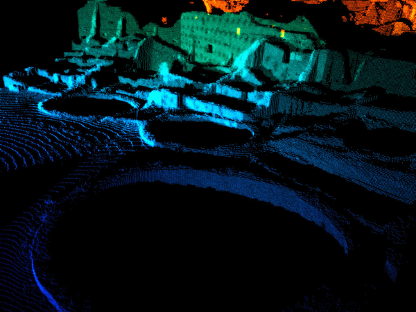
laser scan of Pueblo Bonito by Bohannan Huston, Albuquerque |
If the immense structures of Chaco Canyon were not lived in, then what was their purpose? Was the largest structure, Pueblo Bonito, built as a symbol to the sun? Sofaer claims that the shapes of the buildings have geometry that appears to be solar and lunar. “There is an internal astronomical geometry in the buildings. Bill and I are doing some GPS on smaller sites.”
Hopi astronomer, surveyor, and geodesist Phillip Tuwaletstiwa with The Solstice Project said that the rising sun rises on the wall of Pueblo Bonito on the two equinox days, and the sun sets on this wall only then. The wall also exactly divides day and night only at this time of year, and the wall divides seasons of year and day from night. Chacoan architects had used these same midpoints of the sun to guide their building.
Why did Chacoans go to such trouble? “Some years it was too dry, too hot, too windy, too cold,” Tuwaletstiwa noted. “If there was a way to transfer the orderly nature of the cosmos down to what seems to be chaos down here, then you would be able to integrate heaven and earth. This would then be viewed in Pueblo culture as a center place.”
New Visions of the Past with GIS
Rich Friedman, GIS Coordinator for the Park Service, City of Farmington, spoke on “Interpreting and Reconstructing the Chacoan Landscape – new visions of the past through the use of GIS.”
He asked the question, “Why use GIS with archaeological sites?” The alignment of Pueblo Bonito with the other structures and with roads fanning out from them is important to solving the Chaco mystery. The Chacoans built well engineered roads throughout 95,000 square miles of the southwest, linking their communities.
The construction phases of Pueblo Bonito, designated as 1 through 5, are illustrated on a map which highlights where cylindrical pottery vessels were found. “We can also put z coordinates on it and put it on terrain. It’s pretty difficult to model through stage 3 of the construction – we don’t know how far the foundations went as they tore down a lot and built again,” Friedman explained.
A laser scan of Pueblo Bonito by Bohannon Huston of Albuquerque depicts construction stage 5 done in virtual GIS, all georeferenced to a point in space. “You can’t experience the entire building until you put it in a virtual model,” Friedman said.
Western Mapping mapped the building Casa Rinconada with geodetic referencing and 3D computer animation. They used texture mapping on the walls, and elevation contours to get exact elevation of any niches. The buildings were re-documented with the help of GPS and cross section analysis was done in 3D.
According to Friedman, the roads are a critical element in the geometry. Using aerial photos from 1934 and LiDAR, you can see the roads illuminated, particularly with a light dusting of snow on the land. A 3D terrain model allows you to rotate the sun’s position to see what the site looks like at certain times of the day and year. “LiDAR can’t be artificially enhanced, it’s raw data,” Friedman pointed out.
Introduction to 3D GIS
In a technical session entitled “Introduction to 3D GIS,” Friedman said that it took 32 hours to render a video image of cinematic quality.
In contrast, 3D GIS is simpler. You can use a photo with a 3D model composited into it, and if you have a 3D program you can render out from a view, and use Photoshop.
Major 3D visualization categories for 3D GIS Data included:
3D Terrain Visualization
- terrain hill shading image data overlay (draping)
- GIS data overlay
-GIS data extrusion
3D object placement (may be GIS data driven)
GIS data driven terrain texturing, 3D object placement, and terrain manipulation
Virtual world/Landscape (may use DEM data)
usually needs to be a USGS DEM which requires that you deal with the data differently.
General 3D animation – non- GIS
3D Terrain Visualization software
- terrain hill shading image data overlay (draping)
- GIS data overlay
may include surface generation analysis capability
GIS Data Extrusion extends to
- include the same basic tool set as 3D terrain visualization software
- extends visualization capabilities to the extrusion of GIS data (points, lines and polygons)
- Typically include surface generation analysis capabilities
3D Object placement--
Example software packages-
- Grass/4D Visualization
- ESRI 3D Analyst
- Virtual GIS – add on to ERDAS Imagine
- Autodesk Map 3D 2007
- Map Maker
GIS Data Driven –
Terrain texturing, 3D object placement, terrain manipulation
Includes same basic tool set as 3D terrain visualization and GIS data extrusion with added capabilities - adding 3D objects and using GIS data to drive object placement environment creation and terrain model.
Has capability to create realistic view of a given area based on GIS data and terrain elevation
Near photorealistic and photorealistic images/animation
Sample packages:
- World Construction Set
- Visual Nature Studio (3D nature)
- Genesis II
For photorealistic landscape generation
Example packages:
- Terregen terrain only (free and commercial)
- VistaPro terrains only (inexpensive but not updated in years)
- Vue Esprit
- Bryce ($100)
- MojoWorld
- World Builder
General 3D modeling and animation software
- designed to provide tools to create a variety of 3D products (illustration, animation, game creation, etc.) SketchUp is good for this.
- Typically requires expert knowledge of GIS and 3D data formats to create semi-compatible data.
- Provides the best output (photorealistic)
- Often used in conjunction with software in previous categories.
General Requirements:
“3D” Surface
- DEM
- DTM
-Elevation contours
- survey data (Point clouds, LiDAR)
- GIS data (visualization analysis)
- Image data (visualization/analysis)
- 3D objects – trees, grass, buildings, etc.
Data used for visualization:
GIS data – lines, points and polygons
- polygons are typically used to simulate 3D structures such as buildings, or specifying areas to designate 3D object populations
- points are typically used for locating individual trees, signs, houses, that are typically depicted by discrete point data in a GIS
- Lines for roads and boundaries and other linear features.
2D or not 2D
Some vector data sets have simple 2D coordinates, some have 3D coordinates (i.e. – “Z shape files”)
For 3D visualization, 2D data sets need a source for base Z coordinates:
-elevation attribute
-elevation constant
-“overlay” data onto an existing surface
2D Map
Communicates data in a planar format
can add a hill shaded map – physiographic and planar map combined gives good idea of “before and after” picture
In the 3D world, using a digital orthophoto taken of Pueblo Bonito in 2004, you can see how it looks today versus what it looked like in its first construction stage. Additionally, the animation allows you to show things over time, an important capability for this type of historical project.
GPS survey grade data was used to create a DEM, which revealed where breaks in the terrain were, and used to recreate a model of what the buildings might have looked like.
Casa Rinconada is heavily reconstructed. The entire model using geodetic referencing is oriented within 2 millimeters of ground truth. Thousands of photos were used to create a texture mosaic. Although it is a fairly uncomplicated building, it took four days to scan it with over 300 set ups for scanning, 160 man hours to create the model from the data, a total of four days in the field with a four man crew doing GPS work. “Quite a lot for a two-minute video,” said Friedman.
“Using GIS data to drive your 3D visualizations is a really powerful tool,” Friedman concluded. Watching the Chaco Canyon flythrough, he added: “If we hadn’t done the 3D model, we never would’ve realized the interconnection of roads between Bonito, the other buildings and the rest of the inhabited world of that time.”
Top News of the Week
ESRI (UK) has entered into an asset purchase agreement to buy the Geospatial Solutions Division (GSD) of Tadpole Technology plc for half a million pounds.
The agreed purchase further strengthens ESRI (UK)’s position as GIS market leader in the UK, while adding considerable industry expertise to its portfolio. ESRI (UK) will gain one of the most experienced groups of GIS software consultants in the UK with particular expertise in field-based GIS delivery for government, utilities and national mapping agencies.
SmartDraw.com announced the release of SmartDraw 2008.1, an updated version of its latest software. The new release now features more than 35,000 maps from around the world, as well as revamped image charts.
In addition, SmartDraw 2008.1 offers improved image charts, which enable users to create lively, eye-catching charts that use pictures and images instead of standard bars, lines and circles. Now, image charts are even easier and more intuitive, and feature helpful features such as "one-click fills."
Acquisitions/Agreements/Alliances
In its largest deal to date with the U.S. government, TerraGo Technologies announced that the National Geospatial-Intelligence Agency has licensed Map2PDF, the software used to create GeoPDF® files.
GeoPDF is the only geospatial data distribution and collaboration format that leverages the Adobe Portable Document Format (PDF) to give users powerful mapping functionality and capabilities via Reader®, an application already installed on hundreds of millions of computers worldwide. Utilizing the GeoPDF format, the NGA can extend maps, imagery and attribute data to virtually any computer, making extensive geospatial intelligence available in a portable format that most people already know how to use.
Avalara, provider of web-hosted sales tax management services, announced that it has entered into an exclusive agreement to purchase New Horizons Systems, LLC, a supplier of business geographic and tax jurisdiction assignment software products and data files. By acquiring New Horizons Systems, LLC, Avalara expects to accelerate delivery of next generation services while enhancing its position as the industry's premier accurate sales tax management service provider.
Announcements
The Open Geospatial Consortium, Inc. (OGC(R)) seeks public comment on a draft Sensor Alert Service (SAS) Standard.
The draft OGC(R) Sensor Alert Service standard defines an alert and notification mechanism that specifies how alert or alarm conditions are defined, detected, and made available to interested users. The Sensor Alert Service uses the Extensible Messaging and Presence Protocol (XMPP) to provide the push-based notification functionality. The focus of SAS is on alerts from sensors and sensor webs, a more narrow scope than a complete Web-wide alerting service.
This draft standard can be downloaded from the website.
Image Matters LLC released the source code of gnizr™ Community under the Mozilla Public License. This provides enterprises and individuals with an out-of-the-box Web 2.0 mashup framework for bookmarking, tagging, and sharing Web resources. As an open source project, gnizr will allow developers worldwide to participate in creating the industry’s most advanced Web mashup and social bookmarking framework with spatial capabilities. The open source gnizr and documentation are available under the Mozilla Public License (MPL) at the website.
People
Bohannan Huston, Inc. (BHI) recently hired Loretta Davis as Vice President of Business Development and Marketing. Loretta has 19 years of business development experience in the spatial data, GIS consulting, and IT professional services industries.
Safe Software granted official "FME Certified" accreditation to FME experts from around the world. These individuals are the first to be formally assessed and recognized as part of a new FME Certification Program that is designed to identify training and consulting professionals with deep FME expertise and a proven record of high quality service.
More than 50 individuals in 17 countries have received designation as FME Certified Professional and/or FME Certified Trainer. These highly qualified experts can now reap the benefits that professional accreditation offers.
New Products
ESRI announced the release of ArcGIS Data Appliance, which gives ArcGIS Server users a new way to quickly access terabytes of prerendered, precached nationwide and worldwide data. This data, which had previously only been accessible via the ESRI-hosted ArcGIS Online, is now available within a user's internal network. The data includes satellite and aerial imagery, street and transportation data, place-names, administrative boundaries, topographic maps, shaded relief imagery, and elevation data.
Bentley Systems, Incorporated has begun shipping StormCAD V8 XM Edition, an easy-to-use storm sewer network design and modeling solution that is the first to offer multiplatform interoperability. StormCAD was identified as the No. 1 hydraulic modeling solution for stormwater networks in a recent national survey.
Pizza Holdings, Inc., a wholly owned subsidiary of VTEC, Inc. and home of www.pizza.net, The Original pizza search engine, announced the launch of their New Advanced Technology Pizza Search Engine.
Pizza.net is leading the way in search technology, by combining open source from Yahoo's AJAX Library for a faster web experience, Google's mapping for an enhanced visual address locater, and Geocoding for the zip code proximity searches for increased accuracy.
Autodesk, Inc. announced the availability of Autodesk Topobase Electric software, a new infrastructure management solution designed to help North American electric utilities better manage their transmission and distribution networks, by integrating design and facility asset information. Topobase Electric joins Autodesk’s portfolio of utilities solutions, including Topobase Gas, Water and Wastewater, and Autodesk Utility Design.
For hikers, bikers, travelers and adventurers of all kinds, LocationNation announced the release of the GeoSpatial Media Organizer (GSMO), a free online service for managing and sharing personal Global Positioning System (GPS) data.
Eye-Sys®, a ground-breaking application created to revolutionize data-driven, real-time visualization, has been launched by Interactive Data Visualization, Inc. (IDV).
The software, developed and partially funded through engagements with the U.S. Department of Defense, various research organizations and leading defense contractors, offers unprecedented versatility and an intuitive user interface to meet the demands of visualizing complex and dynamic data of all types.
IDV Solutions announced that its Visual Fusion ServerTM product will utilize the spatial enhancements of SQL Server 2008 to provide customers powerful spatial query support within their visual composite applications. IDV Solutions’ Visual Fusion software also utilizes Microsoft Office SharePoint Server 2007 and Microsoft Virtual Earth to offer a comprehensive visual composite application platform.
Fortified Holdings Corp. ("Fortified" or the "Company") is pleased to announce the launch of its wholly owned subsidiary, Fortified Intelligence, with the general release of its latest product, VantagePoint™ a suite of geospatial mapping software tools that have been specifically developed for laptop and desktop computers, as well as for network servers. VantagePoint provides easy and affordable access for developers to add mapping functionality to virtually any desktop, server or web-based application.
Around the Web
Mapping out safeguards Denver Post, by Chuck Plunkett, November 8, 2007 - One of the many tools that federal agents and Denver police and emergency officials will be using during the 2008 Democratic National Convention is as simple and revolutionary as the so-called mapping mashups you can use on the Internet to find, say, the nearest coffeehouse to your office.
Upcoming Events
| Autodesk University Annual User Conference and Exhibition | |
| Date: | November 27 - 30, 2007 |
| Place: | The Venetian Resort Hotel
Las Vegas, USA |
| The 15th annual Autodesk University (AU) at the Venetian Resort Hotel in Las Vegas is not until November, but if you’d like to teach a class, please submit your ideas by April 30th.
Take a moment to submit your proposal at the AU 2007 website. After providing some personal information about your expertise on a secure server, you’ll be able to submit one or more proposals for classes.
|
|
| Second Annual International Airport GIS Conference | |
| Date: | November 28 - 30, 2007 |
| Place: | Kempinski Hotel
Budapest, Hungary |
| By attending this unique conference, you will learn from European, U.S. and other international airports how and why GIS is being used at large and small airports, as well as the ways in which GIS has made airports safer and more efficient. The primary focus of the conference is to exchange new ideas, success stories and lessons learned on how GIS and related technologies are applied at airports. The conference will include presentations on how airports have used GIS to support security, operations, planning, design, construction, maintenance and much more. New geospatial technologies and approaches for applying these technologies will also be showcased. Additionally, strategies for managing and funding a GIS program will be discussed. The conference will also have an Exhibit Area showcasing the latest GIS-related products and services.
|
|
| Geodiffusion 2007 | |
| Date: | December 3 - 5, 2007 |
| Place: | Montreal, Canada |
| The sixth edition's program will mainly focus on products and solutions from business intelligence and gesopatial industry leaders: PB MapInfo and Oracle. Geospatial Data from global providers will also be part of the agenda.
This event offers a unique chance to acquire expertise, discover new technologies and learn more about geospatial and business intelligence. No matter their industry segments, decision makers and C-level executives, integrators and IT managers, users and GIS experts benefit from this occasion to discuss a subject that matters to them: business intelligence and geospatial. On the agenda: kick-off reception, conferences, breakfast and luncheon meetings, hands-on lab, exhibit hall and dinner.
|
|
| 3rd International conference “Earth from Space - the Most Effective Solutions" | |
| Date: | December 4 - 6, 2007 |
| Place: | R&D Center Scanex
Moscow, Russia |
| The conference is attended by around 300 participants from different countries, representatives of the world leading remote sensing programs, data processing software developers and receiving stations producers, as well as members from different organizations and leading specialist that use remotely sensed data for decision making to resolve a variety of practical tasks: from management of territories and big industrial facilities to real-time monitoring.
|
|
| 3D GeoInfo'07 | |
| Date: | December 12 - 14, 2007 |
| Place: | Aula Conference Centre of Delft University of Technology
Delft, Netherlands |
| The Workshop is intended as an interactive platform for both presentations on state-of-the-art research and discussions on open problems. The workshop will consist of a mixture of single-track presentations and discussion (PD) sessions and parallel working group (WG) sessions on specific themes (Requirements, Acquisition, Modelling, Analysis, Visualisation), according to the following format: current problems to be solved, potential solutions, and recommendations by WG (discussion under coordination of a chair and final presentation of the results at the closing plenary session). The presentations will be selected based on their quality by the scientific program committee (peer review of full papers). The setting of this innovative event will be the ancient city of Delft.
|
|
| b-GIS@Asia 2007 | |
| Date: | December 17 - 19, 2007 |
| Place: | Technopark
Trivandrum, India |
| Trans Asiatic GIS Society is pleased to announce its conference on GIS titled “b-GIS@Asia” from 17th to 19th of December 2007 at Technopark, Trivandrum, India. b-GIS@Asia is about discovering how GIS empowers organizations and demonstrating the role of GIS in organizational business with the intention of urging entrepreneurs, and/or organizations, to invest in GIS for profit or operational performance.
|
|