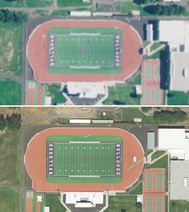
PORTLAND, Ore., Dec. 11, 2018 (GLOBE NEWSWIRE) --
Quantum Spatial, Inc. (QSI), the nation’s largest independent geospatial data firm, announced that a new online offering from the State of Oregon featuring high resolution imagery acquired by QSI is now available to the public for free. The
Oregon Statewide Imagery Program (OSIP) – the largest of its kind in the Western U.S. – contracted QSI to obtain one-foot resolution imagery over the entire state, covering almost 100,000 square miles, as well as process and host current and historical imagery in the
Oregon Imagery Explorer. Through the online portal, users can easily view current images of every location in the state, compare them to past images and download them into their GIS tools at no cost to create base maps, do analysis or leverage for other types of industry-specific applications.
OSIP was developed by Oregon’s Geospatial Enterprise Office (GEO) to meet the increasing demand for up-to-date, high resolution aerial imagery, and make both new and historical imagery available – for free via the web – to every level of government in Oregon, the academic community, private sector businesses, non-governmental organizations and the public. Unlike other publicly available sources, which may provide images that are several years old, the OSIP strives to update the Oregon Imagery Explorer on a regular basis.
“This program was a success largely due to the support from our partners and sister agencies, and the teamwork that went into planning, capturing and publicly launching this new high resolution imagery for the state of Oregon,” said Cy Smith, GISP, State Geospatial Information Officer. “Now we offer a central repository that ensures our users will have the most current images available to support a variety of potential use cases, including transportation and utility planning, vegetation maintenance, emergency management and response, natural resource preservation and restoration, and more.”
OSIP is a cooperative, community-based effort funded by a wide-ranging group of tribal, local, county, regional, state, federal and non-governmental organizations. By banding together on a single statewide image collection project, these groups were able to significantly reduce their costs compared to pursuing similar projects covering smaller territories on their own. The project also gives smaller municipalities or groups that could not afford to acquire imagery an opportunity to access this valuable data, and provides imagery of vast rural areas in the state that wouldn’t typically be covered in more targeted federal, state or local projects.
By working with QSI to collect, process and host the data, OSIP was able to significantly reduce the time it typically takes to make imagery available. QSI also enables users to access both current and historical imagery as REST services, which makes the data easier to leverage for their unique needs.
About OSIP
QSI began working on the OSIP project in Spring 2017, when it was contracted to acquire and process high resolution imagery for the eastern half of Oregon, covering approximately 47,624 square miles. A survey of 52,290 square miles of the western half of the state was completed between July and October 2018.
To collect the imagery, QSI used advanced large format camera sensor technology, Leica ADS100 Aerial Digital Sensors. These sensors create a “pushbroom” system that scans the landscape, enabling more efficient image acquisition, better image quality, reduced flight time and faster processing speed than other solutions. The sensor technology performs optimally over large areas and enabled QSI to collect one-foot imagery across the entire state in an efficient and cost-effective manner. Unlike other statewide collections, which are typically at the one-meter level, the imagery available in the Oregon Imagery Explorer enables users to discern distinct features like structures, pole locations and distribution power lines, with the human eye.
About Quantum Spatial, Inc.
Quantum Spatial, Inc., (QSI) the nation’s largest independent geospatial data firm, provides geographic insights to the largest government and corporate organizations that need geospatial intelligence to mitigate risk, plan for growth, better manage resources and advance scientific understanding. A pioneer in advanced mapping technology, QSI’s end-to-end solutions and services deliver the industry’s highest data quality and accuracy, while leveraging the widest array of technologies for analyzing all types of terrains. Customers use the company’s acquisition, processing, analytics and visualization solutions in a range of technical and scientific disciplines – from geology and biology, to hydrology, forestry and civil engineering. Utilities, oil and gas producers, engineering and construction firms, as well as the military and major government agencies, are QSI customers. QSI has multiple offices around the country. For more information visit quantumspatial.com, join us on
LinkedIn or follow us on Twitter @QuantumSpatial.
A photo accompanying this announcement is available at http://www.globenewswire.com/NewsRoom/AttachmentNg/a3ed9958-bd90-42f7-8029-ebd9a7729ebf
Media Contact:
Maria Bradley
Kickstart Consulting for Quantum Spatial
media@quantumspatial.com
415-509-0498


