SAN JOSE, Calif. — (BUSINESS WIRE) — February 6, 2018 — As the international LiDAR community convenes in Denver, Colorado this week for ILMF (the International LiDAR Mapping Forum), YellowScan’s innovative new Surveyor Ultra system will also take flight – quite literally– with the assistance of Velodyne’s VLP 32C Sensor and the Applanix APX-15 IMU.
This press release features multimedia. View the full release here: http://www.businesswire.com/news/home/20180206005496/en/

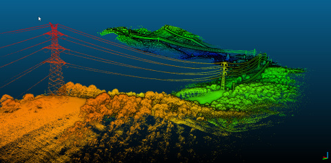
Powerlines & corridor mapping project in Spain - Acquisition made with the YellowScan Surveyor and the DroneQuad4 from Dronetools (Photo: Business Wire)
With 600,000 shots per second, this high-density system catalyzes high-speed UAVs’ capacity to catapult into the sky, so that they can soar, even across long-range flights, as the system can cover up to 100 m. Drones, including VTOLs, can utilize this breakthrough innovation based on its feather-light weight of 1.7kg, through YellowScan’s innovative integration of Velodyne LiDAR’s VLP 32C Sensor.
Like the Surveyor system, the Surveyor Ultra provides users with a turn-key system that can be easily utilized; however, the Ultra will dazzle its users even further, based on its distinctive dimensions of crystal clear under-vegetation 3D modeling, and lightning fast data processing.
This collaborative alliance between YellowScan and Velodyne LiDAR builds on the companies’ previous partnering to deliver a high quality system, as YellowScan utilized Velodyne LiDAR’s VLP-16 Puck and VLP-16 Puck Lite LiDAR Sensors with their singular Surveyor system. Velodyne LiDAR and YellowScan are fully devoted to assisting their clients in virtually taking to the skies and amassing an abundance of mapping data by providing the very latest innovations in inventive and integrated UAV technology. Both companies take great pride in partnering up to provide the contributions our technology makes in surveying, building, and planning.
Therefore, to better equip our clients to be global frontrunners with their UAV capabilities, YellowScan and Velodyne LiDAR have collaborated yet again, with the arrival of the Surveyor Ultra. This system will “provide a higher point density as well as higher flight altitude possibilities,” as Pierre d’Hauteville, YellowScan Head of Sales and Marketing, notes. The professionals who depend on the collaborative potential of our partnership can now rely on drones that can soar higher and transmit high density data accurately and clearly from over long ranges. D’Hauteville comments that, “The Surveyor Ultra completes our product line including the successful Surveyor LiDAR System, with its integration of the VLP-16 scanner from Velodyne.”
With the addition of the Ultra, our clients can acquire intensely vivid mapping images, due to the higher resolution afforded by the 32 channels available on the VLP-32 sensor. Users not only receive real-time, in-flight information during a drone mission, but can now send their drones on image-focused missions, even during challenging weather or environmental conditions. With the Ultra, drones can utilize the lightweight system to recognize objects much more easily and with greater intensity.
Geospatial professionals, as well as other UAV users and adventure seekers, can soar above even the most vegetated terrain below. Inclement weather conditions pose no threat or even obstacles to Ultra adventurers: as YellowScan CTO, Dr. Tristan Allouis asserts, "The Surveyor Ultra shows great potential for safely and efficiently operating LiDAR on lightweight fixed wing UAVs."
You can meet YellowScan at ILMF between February 5-7th, in Denver, Colorado at Booth 509. You can even watch the system itself take flight – again, literally – when the YellowScan team presents a flight and data demonstration in Golden on Thursday, February 8th, with Juniper Unmanned. Join us on this adventure into the air by registering on the YellowScan website : http://www.yellowscan.fr/event/ilmf-asprs-2018.
At YellowScan we design, develop and produce UAV Mapping solutions for professional applications. Fully integrated, ultra-light and easy to use, these highly automated data collection tools are used by customers around the world in fields such as surveying, forestry, environmental research, archeology, corridor mapping, civil engineering and mining.
With more than 12 years of field experience, YellowScan is committed to delivering the highest level of performance, reliability and robustness for its solutions. Our platforms are field tested all over the world in multiple environments (tropical forest, bare soil, mountains, rivers, coast lines, open-pit mine, power lines).
View source version on businesswire.com: http://www.businesswire.com/news/home/20180206005496/en/
Contact:
YellowScan
Nada Jdaini, +33 411 931 427
Marketing &
Communication Manager
Email Contact
or
Velodyne
media contact:
Cesar Alejandro Montero
Email Contact