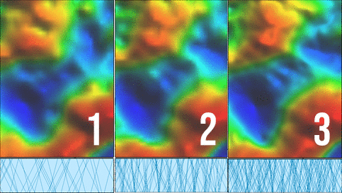
Getech Group has released Multi-Sat 2020 to provide explorers with the highest accuracy and resolution altimetry-derived gravity data available.
Users of Multi-Sat 2020 can take advantage of a dataset that provides previously unattainable confidence in mapping the sub-surface geology, across all of the world’s offshore continental margins.
Getech has long been at the forefront of the generation of gravity from satellite altimetry data and key to the advances of this product, was the successful integration of 12 cycles of altimeter data.
These included 5 cycles from new missions of AltiKa DM and Jason-2 satellites alongside previously processed cycles from the CryoSat-2, Jason-1, ERS-1 and Geosat sensors.
Simon Campbell, Head of Gravity & Magnetic Solutions for Getech, explains in more detail the benefits that explorers all over the world will gain from using Multi-Sat 2020: “The integration of data from multiple satellite cycles and different altimeter modes has enabled us to produce a new, high-resolution 1km gravity grid for all continental margins.”
 “In addition to better resolution and greater accuracy from the enhanced network of satellite tracks, the increased coverage and smaller footprint of the AltiKa data means we now have reliable data closer to the coast (before interference from land reflections kicks in) than has been possible in previous solutions.”
“This enhances geology mapping close to the shore and within the onshore-offshore transition zone, enabling more accurate integration with onshore data.”
“Our customers are now actively using Multi-Sat 2020 in their exploration projects. One recent project highlighted the increased resolution inherent in the data as we were able to correlate intra-sedimentary sand channels observed in seismic data with a subtle, observed gravity response and use Multi-Sat to map the extent and distribution of these potentially prospective channels away from the isolated (and expensive) seismic data.”
“Being able to confidently map such features over large spatial areas allows the user to focus a more cost-effective exploration campaign.”
Click to download the Multi-Sat2020 Product Information